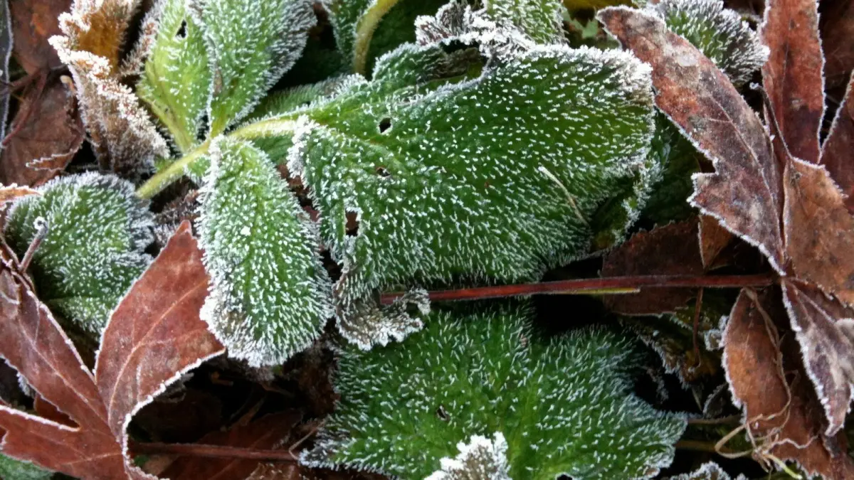
Frost is a layer of ice crystals that forms when a surface such as grass, a car roof or a road cools to 0 °C (32 °F) or below and water vapor in the air turns straight into ice. Black ice is a related hazard: a thin, transparent coat of ice on pavement that looks like a wet road and gives almost no grip.
Both are most common on clear, calm nights from late fall to early spring, often while the official air temperature is still a degree or two above freezing.
Key takeaways
- An air frost occurs when the air temperature, measured about 1.25 m (4 ft) above the ground, falls below 0 °C (32 °F); a ground frost occurs when the grass temperature does.
- Frost can form at ground level with an air temperature of 1–3 °C (34–37 °F), which is why the National Weather Service issues Frost Advisories for lows of 33–36 °F.
- Radiation frost forms on clear, calm nights; advection frost arrives with a mass of freezing air and wind and can last all day.
- Black ice is a thin layer of clear ice on roads, most frequent on bridges, overpasses, shaded bends and tunnel exits.
- Never pour hot water on a frozen windshield: the sudden temperature change can crack the glass.
What is frost?
Frost is ice that forms directly on a surface when that surface falls to freezing point and below the dew point of the air around it, so water vapor deposits as ice crystals without becoming liquid first. That white, feathery coating on lawns and windshields is called hoar frost or white frost.
The coldest moment is usually around sunrise, after the ground has been losing heat all night. To see when the cold season officially begins, read when does winter start 2026.
What temperature does frost form at?
Frost forms when a surface reaches 0 °C (32 °F), but the air temperature in the forecast can be higher at that moment. Official thermometers sit in a ventilated screen 1.25 to 2 m (4 to 6.5 ft) above the ground, following World Meteorological Organization standards, and on a still night the air right at ground level can be several degrees colder.
That is why you can find frosted grass and cars with the forecast or the thermometer showing 1 or 2 °C (34 to 36 °F). A forecast low of 3 °C (37 °F) on a clear, calm night is often enough for frost on the ground.
Ground frost vs air frost: what is the difference?
The difference is where the temperature is measured. The Met Office defines an air frost as an air temperature below 0 °C at screen height, about 1.25 m above the ground, and a ground frost as a temperature below 0 °C measured just above the grass.
| Term | What it means | Who uses it |
|---|---|---|
| Air frost | Air temperature at screen height below 0 °C (32 °F) | Met Office and most national weather services |
| Ground frost | Grass minimum temperature below 0 °C (32 °F) | Met Office forecasts and climate records |
| Frost Advisory | Lows of 33–36 °F (about 1–2 °C) expected, frost likely | US National Weather Service, during the growing season |
| Freeze Watch | Below 32 °F (0 °C) possible within about 12–48 hours | US National Weather Service |
| Freeze Warning | Lows of 32 °F (0 °C) or colder expected | US National Weather Service, during the growing season |
A ground frost often happens on nights when the official low stays above freezing, and for gardeners it is usually what damages young plants.
What types of frost are there?
Frosts are classified by how they form into two main types, radiation frost and advection frost, plus a less common third type caused by evaporation.
| Type | How it forms | Typical conditions | Duration |
|---|---|---|---|
| Radiation frost | The ground loses heat to the sky at night | Clear sky, calm wind, dry air | Overnight; melts after sunrise |
| Advection frost | Wind brings in air that is already below freezing | Wind, sometimes cloud; arctic or continental air | Can last all day and for several days |
| Evaporation frost | Water on plants evaporates and cools them | Very dry air after rain or dew | Local and brief |
Radiation frost is by far the most common. During the day the ground stores heat, and at night it radiates that heat into space. Without clouds to send some energy back or wind to stir the air, the lowest layer of air can end up several degrees colder than the air a few meters higher.
Advection frost arrives with arctic air behind a cold front, freezes day and night over wide areas and is the hardest to protect against.
White frost and black frost
Farmers also distinguish by humidity. In a white frost there is enough water vapor for hoar frost to form, and freezing vapor releases a little heat that slightly softens the damage. In a black frost the air is so dry that no ice crystals appear, the water inside plants freezes unseen, and leaves and buds turn black days later. A black frost is the more damaging of the two, and it is not the same thing as black ice on roads.
Why does frost form on clear, calm nights?
Frost forms most on clear, calm nights because clouds act like a blanket that sends heat back to the ground, and wind mixes the cold air near the surface with milder air above. With neither, overnight cooling is at its strongest.
Cold air is also heavier and drains downhill into valleys and hollows, so a valley floor can be several degrees colder than a slope above it, a pattern called a temperature inversion. Dry air, snow cover and distance from the sea all make frost more likely.
What is black ice and why is it so dangerous?
Black ice is a layer of ice so thin and transparent that the dark asphalt shows through, so the road looks merely wet. It forms when moisture on the road, fog or drizzle freezes, or when meltwater refreezes after sunset, and it is dangerous because drivers do not see it until they lose grip.
Black ice is most likely on:
- Bridges and overpasses, which lose heat from above and below and freeze before the road; many US roads carry "bridge ices before road" signs.
- Shaded stretches, bends under trees and tunnel exits.
- Roads near rivers, lakes or valley floors.
- Any wet road on a clear night when the temperature drops near freezing.
How to drive on black ice
If ice is possible, slow down, leave much more distance to the vehicle ahead, and avoid sudden braking, acceleration or steering. If the car starts to skid, ease off the accelerator and steer gently where you want to go. Many cars show a snowflake symbol when the outside temperature drops below about 3 °C (37 °F): take it seriously, especially on bridges.
How to defrost a windshield safely
Run the engine with the air on the windshield and use a plastic scraper or de-icing spray, never hot water. To prevent ice, cover the windshield overnight and use washer fluid with antifreeze.
How to protect plants from frost
You protect plants from frost by keeping the heat stored in the soil close to them and keeping frost and freezing air off leaves and buds. These steps work in gardens, vegetable beds and on balconies:
- Cover plants at dusk with horticultural fleece, an old sheet or a frost blanket, without plastic touching the leaves, and remove it in the morning.
- Protect plants in pots and containers: group them against a south-facing wall (north-facing in Australia and New Zealand) or under an overhang, raise them off cold ground, and wrap the pots.
- Water in the morning before a frost night: moist soil stores and releases more heat than dry soil. Do not water at dusk.
- Mulch around the base with straw, bark or dry leaves to protect roots.
- Avoid late pruning and nitrogen feeds at the end of the season, which encourage tender new growth.
Mulch also limits frost heave, when water in the soil freezes, expands and pushes newly planted perennials out of the ground. Growers also use frost fans and sprinklers, which work well against radiation frost but much less against advection frost.
How to forecast frost with Clima de Hoy
Clima de Hoy shows minimum temperature, cloud cover, wind and humidity hour by hour, the four clues that tell you whether frost is coming. A clear, calm night with a forecast low near 2 or 3 °C (36 or 37 °F) can already leave frost on the ground.
Check the hourly forecast for London to see when the low arrives, the 7 day forecast for New York to count the frost nights ahead, or the hourly forecast for Burgos if you are driving through Spain's cold high plateau in winter. If a cold snap is coming, read how to stay warm in cold weather too.
Frequently asked questions
At what temperature does frost occur?
An air frost occurs when the air temperature, measured about 1.25 m above the ground, falls to 0 °C (32 °F) or below. The ground can be several degrees colder than that, so frost often forms on grass and cars with the thermometer at 1 or 2 °C (34 to 36 °F).
What is the difference between frost and black ice?
Frost is ice crystals that grow on a surface from water vapor, forming a white coating. Black ice is a thin, clear sheet of ice on a road, formed when moisture, drizzle or meltwater freezes, so the pavement looks only wet. Black ice is far more dangerous for drivers because it is almost invisible.
What does ground frost mean in a forecast?
Ground frost means the temperature just above the grass is expected to fall below 0 °C (32 °F), even if the air at screen height stays slightly above freezing. It is enough to damage tender plants and to leave icy patches on paths and car windows.
Why is frost worst just before sunrise?
Because the ground loses heat all night without any sunshine to replace it, so the lowest temperature usually comes shortly before or just after sunrise. On clear, calm nights this cooling is strongest.
Weather in your city
- Weather in Ciudad de México
- Weather in Londres
- Weather in Nueva York
- Weather in Bogotá
- Weather in Madrid
- Weather in Buenos Aires
- Weather in París
- Weather in Barcelona
- Weather in Valencia
- Weather in Sevilla
- Weather in Málaga
- Weather in Bilbao